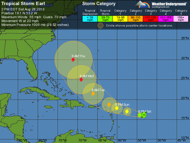
Tropical Storm Earl – August 28, 2010
St. Kitts Meteorological Services
August 28, 2010
A tropical storm watch is now in effect for St. Kitts and Nevis and the rest of the leeward islands. A tropical storm watch means that a tropical storm or tropical conditions poses a possible threat to the specified area within 48 hours. Residents should start to implement their hurricane disaster plans.
Earl is moving toward the west at 21 miles per hour. A turn to the west-northwest with a slight decrease in forward speed are expected over the next couple of days.
Maximum sustained winds are near 60 mph with higher gusts. Additional strengthening is forecast and earl could become a hurricane by tonight.
Tropical storm force winds extend up to 85 miles from the centre.
The estimated minimum central pressure is 999 mb or 29.50inches.
Based on the latest observations and analyses, earl is now expected to pass south of the previous forecast track. The system could now pass within 100 miles of St. Kitts and Nevis.
The storm could begin to affect the islands by Sunday night with peak winds of 60 mph along with higher gusts. Also showers are expected to move across the islands by Sunday morning.
Rainfall totals of up to 5 inches are forecast to occur over a period of less than 24 hours. With this type of rainfall, residents in low lying and flood prone areas should be prepared to move to higher grounds, as major flash flooding is possible . Residents near slopes should prepare to guard against mudslides.
Mariners should stay in port and seek safe anchorage. Seas will start to deteriorate tonight and waves are forecast to exceed 12 feet during the passage of earl.
All residents are urged to closely monitor the progress of earl and to start to implement hurricane plans. A storm or hurricane warning may be required later today.
Image Courtesy of Weather Underground
