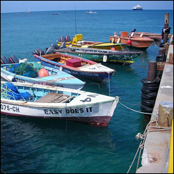
Fishing Boats In Nevis
Basseterre, St. Kitts – Nevis
February 24, 2011 (CUOPM)
St. Kitts and Nevis has set up a Committee to settle disputes and uncertainties regarding the twin-island Federation’s maritime boundaries.
Minister of Tourism and International Transport, Sen. the Hon. Richard Skerrit has informed the Cabinet that St. Kitts and Nevis has overlapping or disputed maritime boundaries with the Netherlands Antilles (St. Eustatius), Venezuela, The French Antilles (St. Barthelemy), Antigua and Barbuda, and Montserrat (effectively, the United Kingdom.
“The Cabinet of Ministers was asked to support a proposal to engage the relevant countries to begin a process of resolution of our maritime boundaries,” Minister of Information, Sen. the Hon. Nigel Carty said following the weekly Cabinet Meeting.
He said that Government believes that there are clear benefits to the resolution of the country’s maritime boundaries.
“Firstly, it will definitively establish the maritime space over which St. Kitts and Nevis will be able to exercise various rights as a matter of international law. For example, a stable basis will be provided for the better management of fisheries and other marine resources. Secondly, the settlement of the maritime boundaries will give rise to better control and monitoring of shipping of dangerous and illicit commodities through our waters. There are of course other benefits,” said Minister Carty.
He said that the Cabinet approved a committee consisting of a wide range of skilled persons that will spearhead the negotiation process for the settlement of our maritime boundaries.
Cabinet Secretary, Mr. Joseph Edmeade said the names of the Committee members will be made public once the individuals have agreed to serve.
OECS Heads of Government in recent years have been giving consistent focus to the subject of the delimitations of our countries’ maritime boundaries.
The governance of the maritime area within the OECS is characterized by unresolved maritime boundaries and related disputes.